This week, we took our first trip abroad since coming to Israel more than seven and a half years ago. Ever since moving to Eilat, I have been fascinated by Aqaba, Jordan, which is readily visible from nearly all parts of our city, and yet it's too far away to see any details. We finally got around to getting our Israeli passports this summer, and so I began to make plans to visit Aqaba. I researched enough to find out that we could take our own car, and this is really what made the trip doable for us, given David's often iffy mobility. So I made the hotel reservations.
Last Sunday morning (6 October 2013), we packed our suitcase and drove over to the border crossing, stopping on the way to fill the car with gas and buy PepsiMaxes to ward off dehydration.
Crossing the border is quite a process. I think it took us a total of about and hour and a half or maybe a little more. The first step was to get the guard to open the gate so we could drive into the Israeli side of the crossing. After talking to us a bit, she had to go all around the car using a big mirror to make sure there was nothing suspicious attached underneath the vehicle. We then parked the car in the Israel crossing station and had to visit about 3 different offices there. They had to check our passports, of course, and we had to get our car registration translated. We had to pay for our exit stamps (I don't remember how much, but we could use our credit card), and we had to pay 16 shekels for the registration translation. Then, equipped with all the properly stamped documents, we proceeded to the gate that would let us out of that area and into the short no-man's-land strip between the Israeli and Jordanian crossing stations.
We had to visit even MORE offices on the Jordanian side, including getting temporary Jordanian registration for the car (complete with white Jordanian license plates) and mandatory car insurance. Finally equipped with the properly stamped Jordanian documents (all in Arabic, of course), we were allowed to leave the crossing area and drive on the Jordanian road away from the border.
Rather than try to go through all the details of our visit to Jordan, I want to talk about some of my main impressions and show you some of the pictures I took.
First, let me say that it was almost like going to another world. Yes, the roads were similar, many of the highway signs were familiar (especially the international symbols), but the feel of the place was just very different in ways that are hard to pin down exactly. It's more the sum total than any one thing, but here are some of the differences I noticed.
Those of you who know me well will not be surprised to hear that one of the first things I noticed was the cars (my first word was "car" even though I couldn't quite say the "r" right yet, and I was able to identify nearly all the cars on the road in the States before I even learned the alphabet!). Of course, there were many models in Jordan that are also in Israel (and even in the U.S.), but there were also a lot that I had either NEVER seen before or seen only very rarely here in Israel. The average age of the cars in Jordan is definitely several years more than in Israel, and the average size is somewhat larger, as well. I think I saw only ONE Prius in Jordan (although they're plentiful here in Eilat, including many taxis), and I don't remember seeing ANY Fiats (besides our own, of course!) The taxis are painted a deep metallic green, which I didn't find very attractive, but at least they're easy to spot!
It wasn't until we had returned home that I realized that I think we didn't see a single scooter, motorbike, or motorcycle in Jordan! They must be illegal there, or people would surely use them, as they do everywhere here in Israel.
There is no regular, scheduled bus service over there, not even in the city. There are a number of small buses (and an occasional larger one) that must operate on some kind of a private basis, but they clearly don't have a regular schedule, line numbers, or bus stops.
There's less traffic over there in general, and people seem quite a bit LESS in a hurry than in Israel. They drive a little bit crazily, but again somewhat LESS than in Israel, and they don't usually go as fast. The typical speed limit in town is 40 kph, which seems to be mostly followed (compared with 50 kph in town in Israel which is almost universally IGNORED!). There are quite a few speed bumps, even on the major roads, so that helps some, too. The speed limit on the open highways well out of town is typically 110 kph for cars, but the traffic there was really quite sparse, at least during our visit.
The roads were very good -- broad divided boulevards in the city and nicely graded highways. The road up Wadi Araba (as the Arava is known in Arabic) was mostly 2-lane, but the highway to Amman is all at least 4 lanes and on divided roadways (at least as far as we went). One reason for this, of course, is that Aqaba has more than twice as many people as Eilat, and it is very important to Jordan since it is the Kingdom's only seaport. And it's growing, too. We saw lots of construction: new neighborhoods, commercial centers, and roads.
Most of the neighborhoods we saw in Aqaba seemed quite decent, although the architecture of the apartments was quite plain and not at all inspiring. We did see one area, though, with clearly substandard housing. We saw no beggars anywhere, however, and the people did not seem to be particularly poor, even though Jordan is still basically a developing country and not at all rich. I also only saw one or two nice villas, but, of course, the nicest ones are probably hidden WELL out of sight.
People tend to cover more of their bodies with their clothes in Jordan. I expected this from the women, but I was a little surprised how many men wore long pants and long-sleeve shirts, even though the weather is still quite hot. David and I, both dressed in short pants and tank tops, really stuck out! Nevertheless, people didn't seem to be paying much attention to us, so I guess it wasn't such a big deal. I saw quite a few men (though FAR from the majority) wearing Saudi-style robes and headdresses. Some, in fact, probably WERE from Saudi Arabia, which is only a short distance down the coast road. In fact, we drove almost all the way down to the Saudi border, turning around just before the actual border crossing station!
The Arabs are well-known to be heavy meat-eaters, and the restaurant menus certainly reflected that. There were never any vegetarian main dishes, and only a few items, such as some salads and a few sandwiches that were meat-free. Nevertheless, we really enjoyed the food there. The selection may have been limited for us vegetarians, but the most of the dishes we did have were delicious! There were LOTS of restaurants near our hotel, and we only got to try a few of them, of course. Breakfasts were included at the hotel, and they were very similar to the ones at Israeli hotels, and very good, too.
I found a shopping district in the downtown area that is kind of like a permanent shuk, with lots of small shops selling all kinds of things, from foods to clothing to household items, and more. A little later, when we were driving on a main road a short distance from there, we passed more than a dozen tire shops in the space of about 3 or 4 blocks!
One of the purposes of our visit was to see what Eilat looks like from over there. So, I'll start the pictures with some views of exactly that. Here's a panoramic view, taken from some distance up from the gulf in Aqaba, that shows the whole city of Eilat:

This one shows somewhat less of the city (only the middle and northern parts), and so it's much easier to see details. It's a particularly nice view of White Mountain and Har Shlomo (Mt. Shlomo) behind it:

This next picture includes all of the Shakhamon neighborhood (where we live) and the large mountain on the left, which we can see clearly from our apartment, as well. I don't know it's name, but it's in Israel (not Egypt), just the other side of Nakhal Shlomo. I've been all the way around it, but I must find out if there's a way to climb to the top of it, because it obviously has a fantastic view!

Here's another view of Eilat, taken from right down by the water in downtown Aqaba:

This one was taken from the same general area as the previous one but looks a little further south and is cropped to include some nice local Aqaba scenery in the extreme lower left (shirtless guys were VERY rare to see; if fact, there were actually 3 or 4 other guys sitting at the end of the pier next to this one, and NONE of them were shirtless!):

I call the next picture "Two Worlds in One Pic" because it show a bit of Aqaba together with almost all of Eilat. Two cities, so close physically, and yet so distant in culture and feel!

We drove down the South Coast of Jordan a couple of times while we were there. This picture is the view looking northward from a point about 5 km north of the Saudi border. Tala Bay, a fancy resort area, is on the right, and Eilat is actually in this view in the distance, although one can hardly make out any of it, really:

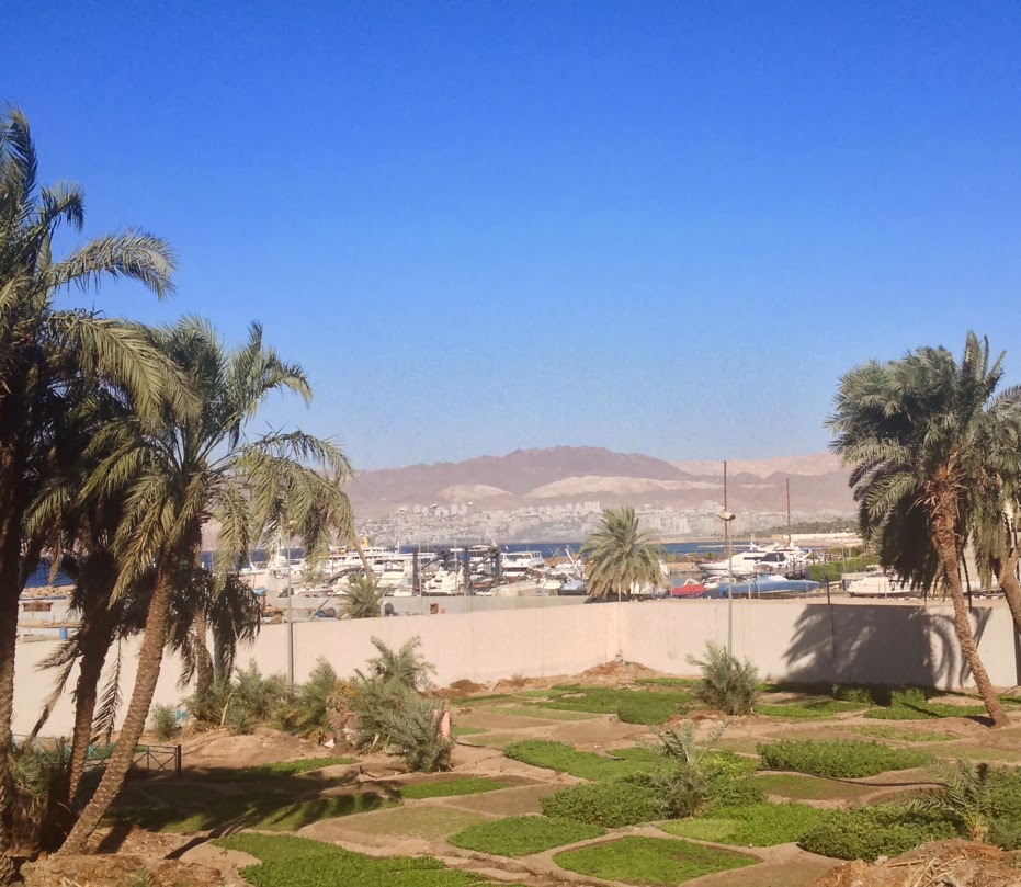
For the next view, we're back in downtown Aqaba. In the foreground, we see some garden patches (I presume some kind of community garden) that are located between the boulevard and the promenade just above the beach. Further back is a marina area, and, in the background, Eilat, White Mountain, and Har Shlomo.
Here's a view from a bit further south, looking northward towards the downtown beach area:

Anyone from Eilat would shoot me if I didn't include at least one picture of the huge flag on the incredibly tall flagpole in Aqaba. According to Wikipedia, the flagpole is 130 meters high and more than 40 cm in diameter at the bottom. The flag itself is 30 meters by 60 meters. This is the main feature of Aqaba that is clearly visible from Eilat. In fact, several important roads in Eilat basically point almost directly towards it. I took this photo from near the north Aqaba port. We're looking north, and the view includes most of downtown Aqaba, as well.

Of course there are MANY mosques in Aqaba. More surprisingly, we saw a very beautiful round modern CHURCH there, too, as evidenced by a cross on top of it.
This next picture shows the minaret and one dome of a particularly beautiful white mosque in downtown Aqaba. I took this picture just at sunset:

This is a picture I took a few minutes later looking up the main road of Aqaba which eventually becomes the highway to Amman:

A little further up that same road, I took this picture, as well, showing a monument and fountain located on the green strip median in the center of the road in honor of the Aqaba Special Economic Zone (kind of a tax-free area similar to Eilat in Israel):

This next picture shows our car, Rosa, with her white Jordanian plates (not as pretty as the yellow Israeli ones she normally wears!), parked right in front of our hotel, the Al Qidra Hotel. Two things I should note in this connection: parking was never a problem for us in Jordan and was ALWAYS free, and I can highly recommend the Al Qidra Hotel for friendliness and good service.

Another important goal of our trip to Jordan was to explore some of the roads I had seen on maps and on Google Earth. One of the interesting ones I found out is called "The Aqaba Back Road". It's mostly for trucks so that they can bypass Aqaba when going to and from the ports. In fact, it's a mandatory route for them, as the signs clearly indicate, even in English. Naturally, we did NOT see many cars on this road, but it was fun "playing with the big boys" on this route. Some of it is 4-lane, some is 2-lane, and some is 3-lane, where the middle lane can be used for passing in either direction (but be careful, of course!). A lot of it is going up or down several quite steep grades, so the trucks are mostly moving VERY slowly. There are 2 or 3 roads that connect this road with various parts of the Aqaba ports, and, in total, there are quite a few escape lanes for trucks that might lose their brakes. These can be seen on some of the steep grades in the U.S., as well. Here's a picture showing a little of the back road with a very pretty mountain:

This is a view looking up the main road from Aqaba to Amman as it goes up a wadi. It's quite a beautiful route!

We also drove up Wadi Araba (as the Arava is called by Jordan). This was another goal of mine, since we've driven up and down the Arava so many times on the Israeli side. Often, I have looked over and seen cars or trucks on the Jordanian side, and I wanted to go on that road myself. Unfortunately, it was quite windy that day, so it wasn't possible to get any good pictures. Also, there was quite a bit of reddish sand blowing across the road and some beautiful sand dunes, mostly on the west side. We drove north to a point somewhere across from the Khiyon stream in Israel (I think I'm remembering that name correctly) and then turned around and drove back south to Aqaba.
Here's one of several signs we saw in Jordan pointing the way back home. The name of our city, אילת, is usually transliterated as "Eilat" in Israel, and occasionally as "Elat", but this sign chose "Ellat". By any name, though, it's our home, and we were glad to get back!

We never bought any gas at all in Jordan. In fact, we still have a quarter of a tank, even after all that driving around there. And that pretty much sums it up: 3/4 of a tank of gas for a trip to and from a different world, right here, practically in our neighborhood.


