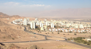
Our unpacking process is beginning to wind down now, since we're virtually all done. So yesterday I decided to take a little hike in the hills back of Eilat near our house.
The road that marks the border of Eilat is only 2 short blocks up from us, so I was into the desert in no time at all. I had spotted the cut of a dirt road going up the side of the hill, so I figured out where it started and headed on up it. Here are some spectacular panoramas of Eilat and beyond from up there.
Here's the view looking about south-southeast. The view includes most of שחמון Shakhamon, our neighborhood. Our building is quite near the center of this photo, but it would be hard to be sure exactly which one it is. The כיכר kikar ("traffic circle") a little to the right of the center is the intersection of our street, עין יהב Ein Yahav, and דרך הרים Derech Harim. The barely visible land on the other side of the Gulf of Eilat (or Aqaba) at the extreme right of the picture is probably far enough south to be in Saudi Arabia. A little to the left of the center is the green strip that I wrote about before. If you look really closely, you may be able to see a modest cruise ship docked in the port of Eilat.
Here's the view looking approximately east. The green strip is barely visible at the right. The כיכר kikar ("traffic circle") in this photo is the top of עין נטפים Ein N'tafim (also the name of the local water company!), the next main street north of ours. The left of this picture is dominated by 3 of a group of 5 of the tallest apartment buildings in town (20 stories!). They are right at the northern corner of the neighborhood. In the distance (but right above the tall buildings in this picture) is the luxury hotel district of Eilat, right at the northern end of the Gulf of Eilat (the eastern branch of the Red Sea). Behind them, even further away, is the city of Aqaba, Jordan (which is why they call this the "Gulf of Aqaba"). Behind Aqaba, of course, are the mountain of Edom.
Here's the view looking northeast. The tall buildings are just barely OUT of this view on the right. The large כיכר kikar in this picture is where highway 12 heads out of town. It first goes west and northwest up into the mountains of Eilat and then heads north. For some distance, it follows very close to the Egyptian border before turning and intersecting with highway 40. This is probably why it is currently closed just after going through a pass in the mountains. Anyway, in this picture you can see most of the rest of Eilat.
I hiked back along highway 12, since the dirt road I was following connected over to it.
There is almost NO vegetation of ANY kind in the hills here, but I did see this one interesting plant along the highway on my way back. I suppose this is the flower, but it could also be a group of leaves, since I didn't see anything else green on the plan at all!
 As I was approaching the city again, I heard a pounding sound. It seemed to come from the direction of the tall buildings. As I looked more closely, I figured out what it was. As you can seen in the picture on the right, they are building a wood roof over the the top מרפסת mirpeset ("balcony") on one of the tall buildings. Look even closer, and you'll see that there's a worker up ON the sloped roof! Now, I like heights and high places, but THIS job would be a little too scary even for ME!


No comments:
Post a Comment