On יום העצמאות Yom HaAtzma'ut ("Independence Day") itself, we decided to take a drive. Since I had read that Uvda Airbase (and airport) was having a Open House, I thought that we might be able to drive up highway 12, which has been closed for several months to most traffic. Sure enough, although the checkpoint is still there, the soldiers manning it said we could travel along it as long as we didn't go left anywhere. They also told us they would be closing it as 6:00 p.m. (long after we planned to be back home, of course).
For the first stretch beginning a little after the checkpoint, it follows the border with Egypt very closely (and you couldn't even go left if you WANTED to!), in several areas going right beside it. As you may have heard, Israel is finally building a strong security fence along this border, all the way from the Red Sea to Gaza (about 240 kilometers, as I recall). Indeed, we could see the obviously new fence, and it's quite impressive. It will not be easily breached. It's tall, made of strong metal, has its upper part slanted towards the other side, and is covered on its upper half by lots of concertina wire (like big loops of lots of barbwire).
Since we've never been on this part of this road before, it was an interesting drive. Eventually, the road turns away from the border somewhat, and it eventually ends at highway 40 at צומת שיזפון Tzomet Shizafon ("the Shizafon Junction"), about 60 kilometers from here. At that point, we turned right on highway 40, drove on it down into the Arava (the southern extension of the Jordan River Valley but extending from the Dead Sea to the Red Sea). There, highway 40 ends at highway 90, which we turned right onto and followed back towards home.
But before arriving in Eilat, we took a side trip on a gravel road I had seen but never gone on before. After some kilometers of rather slow going because of the washboard effect, the road forks. The left fork goes to Shehoret Canyon, which we'll have to check out another time. We took the right fork to Amram's Pillars עמודי אמרם. Before actually getting to the pillars, though, the road ends at a parking area, and one must go on foot another few hundred meters to see the pillars. David stayed in the car, but I took the short hike. Here are some pictures I took.
The first picture show the first view one gets from a distance.
After walking a little further, here's the view. Unfortunately, I was shooting against the sun here, but my iPhone camera did pretty well, and some gamma correction (don't ask, because I don't know) in my graphics program ("Graphic Converter") helped a little, too.
Although it would have been possible, I didn't get any closer than this, since it was quite hot, I was wearing flip-flops (which nevertheless worked just fine), and David was, of course, waiting in the car.
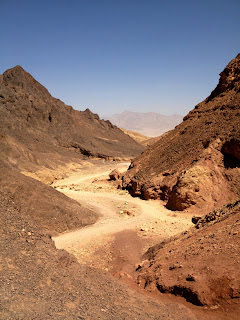
On the north side of the little canyon, I saw this interesting feature. Notice the beautiful layers of varying colors on the lower right side.
Here's the view the opposite direction, towards the east. The car is parked just out of sight in this view, but you can see the Mountains of Edom (in the Kingdom of Jordan, on the other side of the Arava) in the distance.
This is merely a much more cropped version of the picture above. If you look very carefully, you can see a small white spot just above the notch of the nearby hills. If you enlarge the picture, you may even be able to see that it is actually a jet airplane. In fact, it's parked at the Aqaba Airport (in Jordan, of course), and we can also see it from our kitchen and office windows, which face northeast, at home!


2 comments:
Interesting that where you and David live now is as dry as where we are is wet. It's also amazing that you are so close to both Egypt and Jordan.
Is there a trick to getting your photos to line up at the bottom of the page?
Barry, if I highlight a photo, I can choose whether it should be centered, left-justified, or right-justified. Is that what you were asking about?
Post a Comment