In the picture below (which is more towards the right but overlaps a bit with the view above), you can see how the stream itself flows down from the gap near the middle of the picture. That's where the trail is also heading, of course. The trail is somewhat steep but not overly so. When we arrive at the gap, we have to climb up a bit to get through, but metal handholds have been imbedded in the rock to make it much easier.
Here's the view up the stream from the gap. This is actually a short, intermediate section. Near the center of this view, you can see some large boulders. These are at the point where the stream comes out of a larger and much wider valley (I'll call it "the upper valley").
But, before continuing, check out the severely tipped strata to the right of the first gap. Below are two pictures of them. I took the first one on my way up and the second on my way back down, so the angle of the sun was lower in the first than in the second (and they're not from EXACTLY the same spot, either, of course).
Here's a view of the upper valley from the entrance (well, actually the EXIT from the point of view of the stream!). On the way up, it was almost totally in the shade, so the pictures I took were not as good. I took this picture on my way back, when the sun was higher.
This valley is really even more beautiful than the pictures show. Its floor is covered with real sand, like at a nice beach, unlike most of the nakhals I have walked in, which are covered with gravel. The trail goes to the right at the first branching and then left shortly thereafter (I want to go back and explore those other branches sometime, although I'm sure they're not very long).
Here's a view of some pretty old-rose-colored and white sandstone that I saw there. This is on the left side near where the trail turns right and goes up out of the upper valley.
In this next pictures, you can see some interesting layers with contrasting colors. I also thinks it's fascinating the way the hardened mud (well, at least that's what it looks like and maybe once was!) hangs over like the eaves like a thatched roof. If you look closely, you may be able to see a trail marker painted near the lower right, showing that the trail goes up between the exposed strata on the left and the smaller exposed segment on the extreme right.
Below is a close-up view of the layers on the right. Because this shot (even before I cropped it) was TOTALLY in the shade, the camera opened up more, showing the contrasting colors better.
After going up out of the upper valley, we reach a relatively flat area, although it is riddled with canyons, some of them quite deep.
At this point I should probably mention that I bought a large, plastic-coated trail map of this region (in Hebrew) and a book (in English) about hiking in the area. So, now I know the correct names of the nakhals (or wadis) and mountains. The book also tells about the geology of the region, although I don't fully understand all the technical details. In any case, according to the book, many millions of years ago, this area actually WAS a nearly flat plain, and that's what we have reached at this point in the hike. The views in all directions from here are really quite wonderful. Below, you can see some of them.
This first view is approximately in the northwest direction. If you click on the picture to enlarge it, you may be able to see a short section of the new fence along the Egyptian border, just to the left of the small hill at nearly the right side of the picture.
Here's the view in about the south-southwest direction. In the foreground is a very deep canyon (150 meters, according to the book), Nakhal Gishron. On the extreme right, barely visible on the horizon, you can see a nearly flat white mountain. I'm pretty sure this is the same one we see from our balcony and living room and that it is mostly if not totally in Egypt, near Taba, the town on the sea just south of the border. On the left, of course, you can see a bit of the Red Sea.
This is the view further to the left. Here, the sea is more obvious. In the foreground is a pile of rocks that someone built here, and on the left is a hill that goes up a little higher. It looks like it might be pretty easy to go to the top of it from here, and there's no doubt that the view would be fabulous, but that will have to wait for another time.
Here's the view to the east-southeast. On the left you can see a bit of the "upper valley" we came through. Behind that is the rugged mountain the other side of Nakhal Shlomo. Further back, you can see a tiny bit of the Red Sea, and, beyond that, the mountains in Jordan.
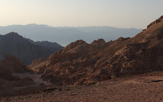
At this point, I turned around and headed back. I'll close with a couple more views, both looking towards the entrance (or, really, EXIT) of the upper valley. The angle of the sun by this time allowed for some pretty dramatic pictures.


No comments:
Post a Comment