Wednesday, May 9, 2012

Nakhal Shlomo

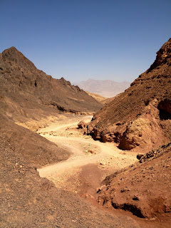
Early yesterday morning (8 May 2012), I decided to take a hike to an area west of here beyond where I had walked before. In that area, there is a cluster of huge fuel or oil storage tanks, which, of course, is surrounded by a strong security fence. I walked on the exterior perimeter road until I got to the other side. After going a short distance further, I saw this beautiful view:
The picture above is looking almost straight west. As I mentioned it was very early in the morning (between 6:30 and 7:00), so the sun was still low. You can see the moon, which was full only a day or two earlier, above the mountain on the other side shortly before moonset (is that a real word?).

The next picture is the view in approximately the south-southwest direction from the same spot. In this view, you can just barely see the Red Sea in the background at the left.
The name of this canyon is actually Nakhal Shlomo (which I learned from the signs). By checking Google Maps satellite view, I could see that the canyon crosses highway 12 some distance up from here, and I knew that spot quite well. It was also apparent from the satellite view and from what I saw yesterday morning, that there was a reasonably good gravel road through this canyon. I figured we could probably make it in our car, so today we decided to give it a try between about 4:30 and 6:00 this evening.

I annotated the satellite view below to show you my hiking route and the route we drove through the canyon. At the extreme right is the location of our apartment, and the route of my walk is marked in hot pink. The route we drove through the canyon is the yellow line that goes from highway 12 in the upper left corner to highway 90, right by the Red Sea, in the lower right corner.
 

Here's a pretty picture I took in the canyon of a rather large acacia tree.
For the next picture I cropped the above picture even more so that you can easily see the REAL reason for the pictures: two ibexes grazing under the tree!


Tuesday, May 1, 2012

Early morning hike to Har Shlomo

Yesterday morning (30 April 2012), I decided to drive up into the Eilat Mountains and do a little hiking instead of walking over to the outdoor gym as I have been doing most mornings. After a drive of about 10 minutes, I parked the car near a camping area and followed the trail to Har Shlomo. The trail goes up to the top of the nearby ridge and then down slightly and over to the next ridge. Although it's not labeled (and the trail DOES go on further), I assume that this was the peak of Har Shlomo ("Mt. Shlomo"). This was at about 6:30 in the morning, so the sun was not yet very far up into the sky. But there were some clouds, so, when the sun got behind one of them, I was able to snap the following picture. The Arava (and part of Aqaba, Jordan, too) is mostly hidden in the early morning haze, but it's still a glorious view with the Mountains of Edom (in the modern-day Kingdom of Jordan) on the other side.

Here's the view looking the other way (west). If you look carefully about half-way up the picture and nearly to the right side, you can see a portion of the fence that Israel is building on the Egyptian border. Beyond the fence, you can even see a building or two in Egypt. A little to the left of the middle and at the bottom of the picture, there is highway 12 just before it goes over the pass and starts going close to the border. There is a checkpoint on the highway just after that, where all vehicles must stop in both directions so that the soldiers can check them out. If they are entering the stretch of highway near the border (going northbound in this case), the soldiers also warn everyone strictly NOT to go anywhere west of the highway (that is, between the highway and the border). This portion of the highway was closed to civilian traffic for several months, and it's still only open from 8:00 a.m. until 5:00 p.m.

Back at the parking lot, here's a view of a hardy tree growing in the campground (with our car parked in the background on the left):

Friday, April 27, 2012

A drive on Independence Day

On יום העצמאות Yom HaAtzma'ut ("Independence Day") itself, we decided to take a drive. Since I had read that Uvda Airbase (and airport) was having a Open House, I thought that we might be able to drive up highway 12, which has been closed for several months to most traffic. Sure enough, although the checkpoint is still there, the soldiers manning it said we could travel along it as long as we didn't go left anywhere. They also told us they would be closing it as 6:00 p.m. (long after we planned to be back home, of course).

For the first stretch beginning a little after the checkpoint, it follows the border with Egypt very closely (and you couldn't even go left if you WANTED to!), in several areas going right beside it. As you may have heard, Israel is finally building a strong security fence along this border, all the way from the Red Sea to Gaza (about 240 kilometers, as I recall). Indeed, we could see the obviously new fence, and it's quite impressive. It will not be easily breached. It's tall, made of strong metal, has its upper part slanted towards the other side, and is covered on its upper half by lots of concertina wire (like big loops of lots of barbwire).

Since we've never been on this part of this road before, it was an interesting drive. Eventually, the road turns away from the border somewhat, and it eventually ends at highway 40 at צומת שיזפון Tzomet Shizafon ("the Shizafon Junction"), about 60 kilometers from here. At that point, we turned right on highway 40, drove on it down into the Arava (the southern extension of the Jordan River Valley but extending from the Dead Sea to the Red Sea). There, highway 40 ends at highway 90, which we turned right onto and followed back towards home.

But before arriving in Eilat, we took a side trip on a gravel road I had seen but never gone on before. After some kilometers of rather slow going because of the washboard effect, the road forks. The left fork goes to Shehoret Canyon, which we'll have to check out another time. We took the right fork to Amram's Pillars עמודי אמרם. Before actually getting to the pillars, though, the road ends at a parking area, and one must go on foot another few hundred meters to see the pillars. David stayed in the car, but I took the short hike. Here are some pictures I took.

The first picture show the first view one gets from a distance.

After walking a little further, here's the view. Unfortunately, I was shooting against the sun here, but my iPhone camera did pretty well, and some gamma correction (don't ask, because I don't know) in my graphics program ("Graphic Converter") helped a little, too.
Although it would have been possible, I didn't get any closer than this, since it was quite hot, I was wearing flip-flops (which nevertheless worked just fine), and David was, of course, waiting in the car.

On the north side of the little canyon, I saw this interesting feature. Notice the beautiful layers of varying colors on the lower right side.

Here's the view the opposite direction, towards the east. The car is parked just out of sight in this view, but you can see the Mountains of Edom (in the Kingdom of Jordan, on the other side of the Arava) in the distance.

This is merely a much more cropped version of the picture above. If you look very carefully, you can see a small white spot just above the notch of the nearby hills. If you enlarge the picture, you may even be able to see that it is actually a jet airplane. In fact, it's parked at the Aqaba Airport (in Jordan, of course), and we can also see it from our kitchen and office windows, which face northeast, at home!


Flags for Israel's 64th birthday

Flags are big here in Israel, especially as יום העצמאות Yom HaAtzma'ut ("Independence Day") approaches (it was yesterday). Here are some pictures. The first one is of a car in our parking lot. Although we've seen thousands of Israeli flags, this is the only Texas flag I've seen! Go figure!

Here's a picture of our car, parked in our lot, decked out with Israeli flags. We bought the one flying from the right back window, but the two that envelop the rear-view mirrors were a gift from שופרסל Shufersal, our favorite supermarket chain, to us loyal customers!

Here are the other flags that we bought at a local toy store, decorating our מרפסת mirpeset ("balcony"). The big one is held up with clothes pins, and the 8 little ones came together on a string that is tied at both ends to the railing. This picture was a little tricky to take, since we're on the 4th (in the States it would be considered the 5th) floor. I had to go out onto the median in the middle of our street to get this shot.


Thursday, April 12, 2012

A tour of Kibbutz Yotvata

Yesterday (Wednesday) we took a fabulous tour of Kibbutz Yotvata, the oldest kibbutz in this area, which is located about a half-hour drive north of here, up the Arava (the valley of the border between Israel and Jordan from the Gulf of Eilat/Aqaba up to the Dead Sea).

Our guide was Moti, a long-time member of the kibbutz. We learned so many things, but I'll try to tell you only about some of them. We drove around the kibbutz as he told us about its history and mode of government (the most democratic possible!).

Then we parked and visited the cows and the factory where the milk products are packaged for shipment. It's truly an amazing operation that they have! Virtually EVERYTHING is computerized: the composition of the cows' food to maintain proper nutrition while minimizing costs, milking the cows, the processing of the milk, packaging the milk products into the containers you see in the stores, putting the containers in packages, putting the packages onto pallets, etc. Moti said that one of their key objectives is minimizing the amount of human labor required.

For example, in the milking room, the cows walk one at a time onto a HUGE carousel that is very slowly turning. As soon as a cow is in place, there are 2 workers who hook her tits up to the milking machine. The compter takes care of the rest (I suppose there was at least one person on the other side to unhook them): identifying the exact cow based on a device she wears, sensing when she is dry and turning the suction off, and recording exactly how much milk she gave. The cows are milked in this fashion three times every day. The computer knows about every single cow, including who her parents and grandparents were!

A couple other examples were the robots we saw in the milk processing factory. One of them was actually designed by a student at the regional school located at Yotvata as his 12th-grade project! Another of them, which was actually working during our visit, was picking up 6-packs of bottles of chocolate milk (the signature product of Yotvata!) 3 at a time (18 bottles) as they came off of the line from the machine where they had been filled and sealed. It then turned around about 180 degrees and deposited them at the correct position on a palet. When one level of the pallet was full, the robot picked up a separator board and put it precisely on top of them so that another level of 6-packs could be placed. When the pallet was full, it automatically proceeded to the next machine, which picked it up and turned it round and round, wrapping it in plastic shrink wrap to keep it together for shipping. We saw only two workers on the floor making sure everything was going fine.

From the milk factory, we continued our tour on the other side of the highway (Highway 90). This is where Yotvata's fields and palm groves are. This is also the area where they do various plant science experiments. For example, they had several rows of palm trees that were growing in HUGE round containers that were actually on scales. The trees got varying amounts of water of varying levels of salinity (salt content). The water they got and the amount they actually used is all very carefully measured (that's the reason they're on scales), and it was obvious that the trees receiving saltier water weren't growing as fast. Moti said they were also less productive.

Another ongoing experiment of theirs involves growing various flowering plants, both local natives and species from other arid area of the world. The goal here is to find, breed, and develop plants that look nice in landscaping but require very little water (what we called "xeriscaping" in California). Here's a picture of part of that area, where you can truly see the desert blooming!

Yotvata's fields and palm groves go right down to the Jordanian border. On the other sides, you can see the sand dunes, showing us exactly what the entire area looked like originally. Once Jordan and Israel had signed their peace agreement, the Jordanians began to ask why none of this kind of work was happening on their side of the Arava. Gradually, they developed a relationship with Yotvata whereby the kibbutz helped them develop agriculture in Jordan. At first, the kibbutz members had to travel almost all the way to Eilat to cross the border at the crossing located there. The Jordanians had no trouble with the idea of them simply entering Jordan right at Yotvata, but the Israeli government was naturally worried about the possibility of smuggling and infiltration. So, they worked out a system that allows 11 members of the kibbutz to cross, using 2 keys, one that they have and one that a Jordanian official on the other side has. Jordan even built a guard station on their side, NOT to protect Jordan but to protect Yotvata!

It really was a fascinating tour, and it was amazing and inspirational to see what this kibbutz has accomplished and continues to do. I highly recommend it!

More "Egyptians" from the mall

This morning, when I stepped out my door (into the 4th-floor lobby of our building), here's what was lying right in front of it:
It seems that the friendly Egyptian woman from the mall has now brought 3 of her friends right to our doorstep, literally! Just above the 4 Egyptians in the picture, it says, "The management of Mul HaYam (the name of the mall, which means "by the sea") wishes the residents and guests of Eilat a Kosher and Happy Holiday of Freedom." Interestingly enough, the big sale that they're advertising ends TODAY, so the flyer is really a little late, don't you think?

Tuesday, April 10, 2012

Happy Passover from ... an Egyptian?

Pesach (Passover) in Israel can be very interesting. Some examples:

• כשר לפסח kasher l'pesakh Kosher for Passover bread! Yes, at nearly all the restaurants that regularly serve bread, such as the popular chain Café Café.

• כשר לפסח kasher l'pesakh Kosher for Passover pizza! That's what we ate at the local mall today, and it was at least as good as regular pizza.

• the hanging sign right in the middle atrium of the local mall, shown in this picture, which I snapped yesterday:
Perhaps this is just the triumph of capitalism over everything, but there's something slightly unsettling about a picture of a traditional Egyptian with the words חג פסח שמח khag pesakh sameakh ("Happy Passover Holiday") emblazoned on her dress! Of course the bags saying "Fashion Sale" would be pretty normal at virtually any mall in the world and at any time of year deemed appropriate.