I've just started a new project that I've been intending to do for a LONG time.
Way back in the 1950's, from 1951 right after she got married until 1958, my mom wrote letters from Loma Linda, California, to her parents in Phoenix, Arizona. This includes the time when both I and my younger brother were born! Her mother carefully kept the letters, many in their original envelopes. Much later, after grandpa and grandma had moved to California, my mom got the letters, perhaps even after her parents had died. In any case, we got them when we sold my mom's house and have kept them safe ever since. But I had never taken the time to actually look at them.
My project now is not only to read them but also to type them into the computer so they will be safe for posterity. I suppose I actually COULD scan them and do OCR (almost all of them were typed -- after all, my mom had been a typing teacher!). But it seems more interesting to type them in myself.
They were already sorted into years, but not necessarily WITHIN each year. So, I have started with 1951, the first year. I began by sorting the letters from that year by date, and now I am typing them in, one by one.
The "voice" in the letters is very much that of my mom as I always knew and loved her. She is always very positive about everything and everyone. But she's no Pollyanna. After all, when these letters were written, she was still recovering from the terrible car accident in which she had broken BOTH her legs (the UPPER parts!). She was walking by this time (something the doctors had early on thought she might NEVER do again), but she still had pain in her legs, and she still used crutches some of the time. These facts come up from time to time, but the tone of the letters is utterly positive. Of course, the fact that she was also a newlywed helped. She also had the most wonderful things to say about my dad, and I know from my own experience growing up with both of them that she was right. The man she describes is exactly like the dad I knew, as well, always helping with the work, and always completely supportive of mom.
Already the things she talks about are interesting, and I even knew some of the people she mentions. But it should get REALLY interesting when I get to the parts for which I was actually present. Naturally, I don't remember too many things from the 50's, but I may find that I'll remember some of them, and I'll get a LOT of fill-in about my own early childhood. It should be interesting!
So, stay tuned, and I'll try to post again from time to time about this project. Perhaps I'll even share a few quotes from my mom. If she were writing now, in the early 21st century, she'd probably be doing a blog, too!
Monday, June 25, 2012
Wednesday, June 13, 2012
Early morning hike up Nakhal Yoash
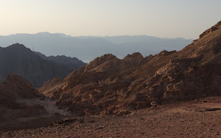
Yesterday morning (12 June 2012) I hiked up a trail I had never been on before. It starts from Highway 12 a short distance after the highway begins to climb out of Nakhal Shlomo on the west side (about a 14-minute drive from our house). The wadi is called Nakhal Yoash. I had seen the trail from the highway, and it looked interesting. In the picture below, you can see where it begins to climb and how it goes near the edge of the tipped strata. This is practically right beside the highway and easily visible from it.

In the picture below (which is more towards the right but overlaps a bit with the view above), you can see how the stream itself flows down from the gap near the middle of the picture. That's where the trail is also heading, of course. The trail is somewhat steep but not overly so. When we arrive at the gap, we have to climb up a bit to get through, but metal handholds have been imbedded in the rock to make it much easier.


But, before continuing, check out the severely tipped strata to the right of the first gap. Below are two pictures of them. I took the first one on my way up and the second on my way back down, so the angle of the sun was lower in the first than in the second (and they're not from EXACTLY the same spot, either, of course).


In this next pictures, you can see some interesting layers with contrasting colors. I also thinks it's fascinating the way the hardened mud (well, at least that's what it looks like and maybe once was!) hangs over like the eaves like a thatched roof. If you look closely, you may be able to see a trail marker painted near the lower right, showing that the trail goes up between the exposed strata on the left and the smaller exposed segment on the extreme right.

Below is a close-up view of the layers on the right. Because this shot (even before I cropped it) was TOTALLY in the shade, the camera opened up more, showing the contrasting colors better.


Here's the view in about the south-southwest direction. In the foreground is a very deep canyon (150 meters, according to the book), Nakhal Gishron. On the extreme right, barely visible on the horizon, you can see a nearly flat white mountain. I'm pretty sure this is the same one we see from our balcony and living room and that it is mostly if not totally in Egypt, near Taba, the town on the sea just south of the border. On the left, of course, you can see a bit of the Red Sea.

This is the view further to the left. Here, the sea is more obvious. In the foreground is a pile of rocks that someone built here, and on the left is a hill that goes up a little higher. It looks like it might be pretty easy to go to the top of it from here, and there's no doubt that the view would be fabulous, but that will have to wait for another time.

Here's the view to the east-southeast. On the left you can see a bit of the "upper valley" we came through. Behind that is the rugged mountain the other side of Nakhal Shlomo. Further back, you can see a tiny bit of the Red Sea, and, beyond that, the mountains in Jordan.


In the picture below (which is more towards the right but overlaps a bit with the view above), you can see how the stream itself flows down from the gap near the middle of the picture. That's where the trail is also heading, of course. The trail is somewhat steep but not overly so. When we arrive at the gap, we have to climb up a bit to get through, but metal handholds have been imbedded in the rock to make it much easier.

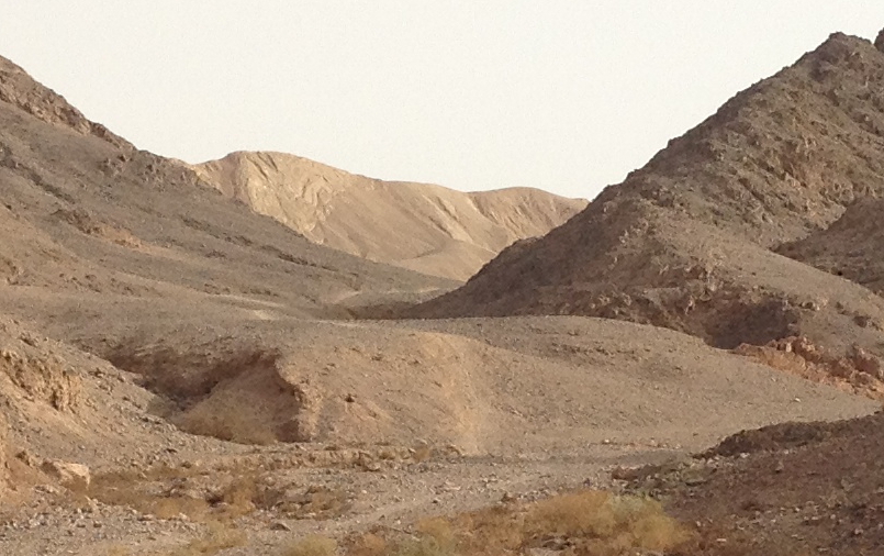
Here's the view up the stream from the gap. This is actually a short, intermediate section. Near the center of this view, you can see some large boulders. These are at the point where the stream comes out of a larger and much wider valley (I'll call it "the upper valley").

But, before continuing, check out the severely tipped strata to the right of the first gap. Below are two pictures of them. I took the first one on my way up and the second on my way back down, so the angle of the sun was lower in the first than in the second (and they're not from EXACTLY the same spot, either, of course).


Here's a view of the upper valley from the entrance (well, actually the EXIT from the point of view of the stream!). On the way up, it was almost totally in the shade, so the pictures I took were not as good. I took this picture on my way back, when the sun was higher.

This valley is really even more beautiful than the pictures show. Its floor is covered with real sand, like at a nice beach, unlike most of the nakhals I have walked in, which are covered with gravel. The trail goes to the right at the first branching and then left shortly thereafter (I want to go back and explore those other branches sometime, although I'm sure they're not very long).
Here's a view of some pretty old-rose-colored and white sandstone that I saw there. This is on the left side near where the trail turns right and goes up out of the upper valley.

In this next pictures, you can see some interesting layers with contrasting colors. I also thinks it's fascinating the way the hardened mud (well, at least that's what it looks like and maybe once was!) hangs over like the eaves like a thatched roof. If you look closely, you may be able to see a trail marker painted near the lower right, showing that the trail goes up between the exposed strata on the left and the smaller exposed segment on the extreme right.

Below is a close-up view of the layers on the right. Because this shot (even before I cropped it) was TOTALLY in the shade, the camera opened up more, showing the contrasting colors better.

After going up out of the upper valley, we reach a relatively flat area, although it is riddled with canyons, some of them quite deep.
At this point I should probably mention that I bought a large, plastic-coated trail map of this region (in Hebrew) and a book (in English) about hiking in the area. So, now I know the correct names of the nakhals (or wadis) and mountains. The book also tells about the geology of the region, although I don't fully understand all the technical details. In any case, according to the book, many millions of years ago, this area actually WAS a nearly flat plain, and that's what we have reached at this point in the hike. The views in all directions from here are really quite wonderful. Below, you can see some of them.
This first view is approximately in the northwest direction. If you click on the picture to enlarge it, you may be able to see a short section of the new fence along the Egyptian border, just to the left of the small hill at nearly the right side of the picture.

Here's the view in about the south-southwest direction. In the foreground is a very deep canyon (150 meters, according to the book), Nakhal Gishron. On the extreme right, barely visible on the horizon, you can see a nearly flat white mountain. I'm pretty sure this is the same one we see from our balcony and living room and that it is mostly if not totally in Egypt, near Taba, the town on the sea just south of the border. On the left, of course, you can see a bit of the Red Sea.

This is the view further to the left. Here, the sea is more obvious. In the foreground is a pile of rocks that someone built here, and on the left is a hill that goes up a little higher. It looks like it might be pretty easy to go to the top of it from here, and there's no doubt that the view would be fabulous, but that will have to wait for another time.

Here's the view to the east-southeast. On the left you can see a bit of the "upper valley" we came through. Behind that is the rugged mountain the other side of Nakhal Shlomo. Further back, you can see a tiny bit of the Red Sea, and, beyond that, the mountains in Jordan.

At this point, I turned around and headed back. I'll close with a couple more views, both looking towards the entrance (or, really, EXIT) of the upper valley. The angle of the sun by this time allowed for some pretty dramatic pictures.


Friday, June 1, 2012
Acromania strikes again!
Yesterday morning (Thursday), I hiked of the tall hill nearest to our place. I actually wasn't sure I'd be able to do it.
Shortly after we arrived here, I had taken a short afternoon walk on the gravel road that goes part of the way up the hill. I took some great pictures from there and, I believe, did a post about it here. That part, of course, is easy, since there's an actual road. Above that, however, there is NO road, and the hill is VERY rugged and rocky, with lots of small, loose rocks under one's feet. There IS a trail (not marked, but still visible), but it's very steep, going up a narrow ridge. In fact, going UP is really the easy part; it's coming DOWN that's a bit more tricky. This is something I'm always keenly aware of as I ascend: how will it be when I'm coming back down?
I arrived at the top quite suddenly and gave a great gasp of joy! The view, of course, is spectacular in all directions. The top of the hill is actually a fairly broad ridge with 3 distinct peaks near the same height. The trail comes up just to the right of the middle peak, so that's where I went first. Here are cropped versions of 3 of the many pictures I took from there.
The first one is the view approximately south-southeast. On the left is the lowest of the 3 peaks. To the right of it, you can see the extreme southeast corner (and newest part, including continuing construction) of the Shakhamon neighborhood (and of the city of Eilat, in fact). Behind all of this, of course, is the Red Sea. The mountains lost in the distant haze are probably in Saudi Arabia, but the more visible ones on the left are in Jordan.


Next, I walked over to the highest peak of THIS hill, of course. Here's the view from there with the somewhat tattered flag in the foreground. Nevertheless, it waves proudly here, as well it should! Just above the flag you can see the white mountain that I climbed to the top of and wrote about here just a while back.

Finally, here's the view in approximately the south-southwest direction. The very distant mountains on the right are definitely in Egypt. If you click on the picture to enlarge it, you may be able to see a little of a white mountain with a fairly flat top, well to the right of the center. I'm quite sure both that this is in Egypt and that it's the same one we can see on clear days from our מרפסת mirpeset (balcony).

Indeed, it WAS pretty tricky coming down, but I made it safely without so much as even a small scratch on my legs, arms, or hands (I was wearing only shorts, a tanktop, and socks and shoes). I will say, though, that my leg muscles were still just slightly sore this morning.
Shortly after we arrived here, I had taken a short afternoon walk on the gravel road that goes part of the way up the hill. I took some great pictures from there and, I believe, did a post about it here. That part, of course, is easy, since there's an actual road. Above that, however, there is NO road, and the hill is VERY rugged and rocky, with lots of small, loose rocks under one's feet. There IS a trail (not marked, but still visible), but it's very steep, going up a narrow ridge. In fact, going UP is really the easy part; it's coming DOWN that's a bit more tricky. This is something I'm always keenly aware of as I ascend: how will it be when I'm coming back down?
I arrived at the top quite suddenly and gave a great gasp of joy! The view, of course, is spectacular in all directions. The top of the hill is actually a fairly broad ridge with 3 distinct peaks near the same height. The trail comes up just to the right of the middle peak, so that's where I went first. Here are cropped versions of 3 of the many pictures I took from there.
The first one is the view approximately south-southeast. On the left is the lowest of the 3 peaks. To the right of it, you can see the extreme southeast corner (and newest part, including continuing construction) of the Shakhamon neighborhood (and of the city of Eilat, in fact). Behind all of this, of course, is the Red Sea. The mountains lost in the distant haze are probably in Saudi Arabia, but the more visible ones on the left are in Jordan.

The picture looks about southeast. Now, the lowest of the 3 peaks is on the right of the picture. Our building is barely hidden behind it from here, but you have a fantastic view of our neighborhood's beautiful green strip. The mountains the other side of the Sea are, of course, in Jordan.

Here's the view looking northwest towards the highest peak. You can see the flag on it. In the distance is הר שחמון Har Shakhamon, which is probably the highest mountain in this area (though I'm sure the mountains across the valley in Jordan are higher). It is VERY rugged, but I must investigate sometime the possibility of getting to the top of it, or as near as I can. We'll see...

Next, I walked over to the highest peak of THIS hill, of course. Here's the view from there with the somewhat tattered flag in the foreground. Nevertheless, it waves proudly here, as well it should! Just above the flag you can see the white mountain that I climbed to the top of and wrote about here just a while back.

Finally, here's the view in approximately the south-southwest direction. The very distant mountains on the right are definitely in Egypt. If you click on the picture to enlarge it, you may be able to see a little of a white mountain with a fairly flat top, well to the right of the center. I'm quite sure both that this is in Egypt and that it's the same one we can see on clear days from our מרפסת mirpeset (balcony).

Indeed, it WAS pretty tricky coming down, but I made it safely without so much as even a small scratch on my legs, arms, or hands (I was wearing only shorts, a tanktop, and socks and shoes). I will say, though, that my leg muscles were still just slightly sore this morning.
Tuesday, May 22, 2012
Spectacular views of Eilat and beyond
This morning I took another hike in the hills. In order to save a little time, I started by driving the car to a spot a short distance up highway 12. The drive took about 6 minutes, but it would have taken 15-20 minutes to walk there.
From that point, there is a bicycle trail through the hills over to Nakhal Shakhamon. In fact, there are LOTS of bicycle trails like this in the hills near here. They might be just a bit scary for me to ride my bike on (I haven't actually tried yet), but they are GREAT for hiking!
When I reached Nakhal Shakhamon, I followed the gravel road for a short distance and then turned left on a trail in a narrower canyon. The trail is well marked, but it shortly begins to go up a very steep part of the canyon towards a saddle. Even from way down, one can see that there are two power-line towers up in the saddle. In fact, there is even a gravel road up the other side, but I didn't know that until I got up there, of course. Nevertheless, the route around the mountain to the road would have been MUCH longer, and the steep trail was very beautiful.
From the saddle, it's only a short hike up the ridge to the peek of the mountain.
But, let's back up a bit. Here's a view of the mountain as seen from our laundry-room window. Of course, I cropped the original severely to show you just the mountain!

Here's another very cropped picture showing you the view of the mountain from where I parked the car.
But the really spectacular views, of course, are from the top of the mountain itself. I took all three of the following pictures from the summit. These are all cropped from their originals. The first one shows the view looking north-northeast. On the right side in the foreground, you can see the ridge of the mountain, and to its left is the valley on the west side (you can see the power-line gravel road at the bottom of it). In the distance, you can see far up the Arava, and, in the upper right you can see some of the mountains in Jordan.

Here's the view looking approximate east-southeast. You can see most of Aqaba, the end of the eastern branch of the Red Sea (the Gulf of Aqaba or the Gulf of Eilat), and most of Eilat (except our neighborhood).

This last view is slightly less cropped than the one above and looks approximately southeast. This one shows most of Eilat, except for the northern parts and the hotel district. In this view, the mountains that are barely visible on the other side of the Gulf at the extreme right of the picture are probably in Saudi Arabia. The other mountains, of course, are in Jordan. Although not shown in any of these pictures, I could also see mountains to the south that are in Egypt.

Monday, May 14, 2012
Early-morning hike to Mitzpe Y'rokham
This morning (Monday, 14 May 2012), I decided to drive up into the Eilat Mountains and then take a hike on the top of the world. First, I took the trail to Har Shlomo, which I had taken several weeks ago (and about which I posted here, with pictures). But this time, I continued further on the trail, descending a little on the east side of the mountain and continuing on a ridge towards the east. Here's a view of the trail. Near the bottom left corner, you can see the trail marker painted on a rock. The big, dark-colored mountain that dominates the picture I believe is called Har Shakhamon (Mt. Shakhamon, the same as the name of our neighborhood, which is on the opposite side of this mountain). To the right and below the mountain is the upper end of Nakhal Shlomo. In a previous post, I told about our drive down this nakhal (or wadi) to the sea, but that was in its lower part which is not visible from here. Two days ago, I parked the car at the point where the highway is about to go up out of this nakhal and hiked on the trail you can clearly see down in the valley in this view.

Here's another view of this morning's trail. This is the final stretch before reaching Mitze Y'rokham (the Y'rokham Viewpoint). As you can see, the trail passes along a rather narrow ridge at this point, with quite steep drops on both sides, definitely an acromaniac's delight (okay, I actually invented that word, but think of it as the opposite of someone who has acrophobia, the fear of heights). Yes, that's the sun in the upper left, trying to shine through the early-morning cloud cover.

Here's the view of Har Shakhamon and Nakhal Shlomo from Mitzpe Y'rokham:

Here's the view looking northeast from Mitzpe Y'rokham. On the right, you can see just a bit of Aqaba, Jordan, and all across the background are the Mountains of Edom (in the modern-day Kingdom of Jordan, of course). At the bottom of the picture, you can see the signs telling us (in Hebrew and English) the names of some of the key features we can see from here.

The trail actually continues further, over towards Har Shakhamon. In fact, it may even continue to the summit. However, the first thing after Mitzpe Y'rokham is a nearly vertical descent. I was out of time for this hike, but even I hadn't been, this might have been a little too much even for THIS acromaniac! I actually took a couple of pictures of the descent, but neither of them gives ANY IDEA at ALL of how really steeply down it goes!
Wednesday, May 9, 2012
Nakhal Shlomo
Early yesterday morning (8 May 2012), I decided to take a hike to an area west of here beyond where I had walked before. In that area, there is a cluster of huge fuel or oil storage tanks, which, of course, is surrounded by a strong security fence. I walked on the exterior perimeter road until I got to the other side. After going a short distance further, I saw this beautiful view:

The next picture is the view in approximately the south-southwest direction from the same spot. In this view, you can just barely see the Red Sea in the background at the left.

I annotated the satellite view below to show you my hiking route and the route we drove through the canyon. At the extreme right is the location of our apartment, and the route of my walk is marked in hot pink. The route we drove through the canyon is the yellow line that goes from highway 12 in the upper left corner to highway 90, right by the Red Sea, in the lower right corner.

Here's a pretty picture I took in the canyon of a rather large acacia tree.


Tuesday, May 1, 2012
Early morning hike to Har Shlomo
Yesterday morning (30 April 2012), I decided to drive up into the Eilat Mountains and do a little hiking instead of walking over to the outdoor gym as I have been doing most mornings. After a drive of about 10 minutes, I parked the car near a camping area and followed the trail to Har Shlomo. The trail goes up to the top of the nearby ridge and then down slightly and over to the next ridge. Although it's not labeled (and the trail DOES go on further), I assume that this was the peak of Har Shlomo ("Mt. Shlomo"). This was at about 6:30 in the morning, so the sun was not yet very far up into the sky. But there were some clouds, so, when the sun got behind one of them, I was able to snap the following picture. The Arava (and part of Aqaba, Jordan, too) is mostly hidden in the early morning haze, but it's still a glorious view with the Mountains of Edom (in the modern-day Kingdom of Jordan) on the other side.

Here's the view looking the other way (west). If you look carefully about half-way up the picture and nearly to the right side, you can see a portion of the fence that Israel is building on the Egyptian border. Beyond the fence, you can even see a building or two in Egypt. A little to the left of the middle and at the bottom of the picture, there is highway 12 just before it goes over the pass and starts going close to the border. There is a checkpoint on the highway just after that, where all vehicles must stop in both directions so that the soldiers can check them out. If they are entering the stretch of highway near the border (going northbound in this case), the soldiers also warn everyone strictly NOT to go anywhere west of the highway (that is, between the highway and the border). This portion of the highway was closed to civilian traffic for several months, and it's still only open from 8:00 a.m. until 5:00 p.m.


Here's the view looking the other way (west). If you look carefully about half-way up the picture and nearly to the right side, you can see a portion of the fence that Israel is building on the Egyptian border. Beyond the fence, you can even see a building or two in Egypt. A little to the left of the middle and at the bottom of the picture, there is highway 12 just before it goes over the pass and starts going close to the border. There is a checkpoint on the highway just after that, where all vehicles must stop in both directions so that the soldiers can check them out. If they are entering the stretch of highway near the border (going northbound in this case), the soldiers also warn everyone strictly NOT to go anywhere west of the highway (that is, between the highway and the border). This portion of the highway was closed to civilian traffic for several months, and it's still only open from 8:00 a.m. until 5:00 p.m.

Back at the parking lot, here's a view of a hardy tree growing in the campground (with our car parked in the background on the left):

Subscribe to:
Posts (Atom)